Reaching to the world’s highest Tilicho Lake (4949m/12235ft), crossing the world’s highest Thorung La Trekking Pass (5416m/17765ft) and driving through the world’s deepest Rupse Chhahara Gorge (6617m lower from two Himalayan giants’ Dhaulagiri and Annapurna) are highlights of the trip.

Annapurna Tilicho Lake Trek Program Highlights Include 

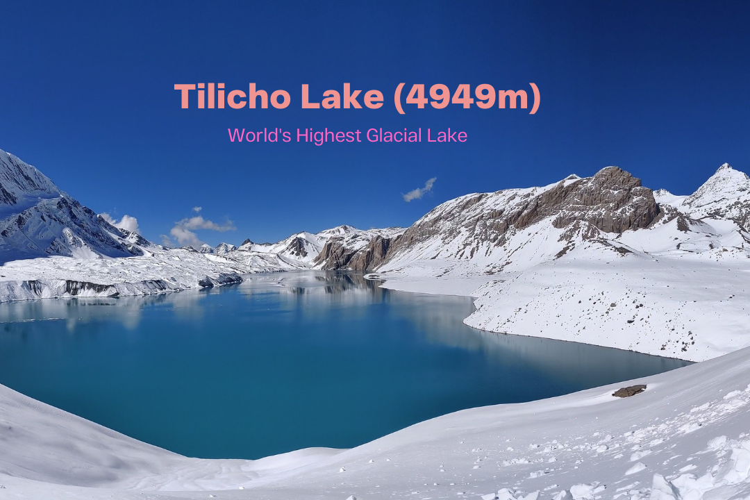
  • Crossing the world’s highest trekking Pass (ThorungLa -5416M), reaching to the world’s highest lake (Tilicho Lake -4949M) and trekking through the world’s deepest gorge (Rupse Chhahara -6617M lower from two Himalayan giants; Dhaulagiri and Annapurna)
  • Most fascinating and popular trekking routes in the world, taking one through an amazing diversity of terrain and culture; from lush green foothills with pretty terraces and picturesque Gorkha villages to barren, Tibet-like landscape; through deep forested gorges and the high Throung pass, through Buddhist villages with ancient cliff-top lamaseries to settlements that were one great marts of the trans-Himalayan barter trade.
  • Close up views of 03 of the 14 eight thousander (8000M+ mountains); Dhaulagiri (8167m –world’s 07th highest), Manaslu (8163M -08th highest), Annapurna I (8091M –world’s 10th highest) as well as five other major peaks; Annapurna II, Annapurna III, Annapurna IV, Annapurna South and Gangapurna. Nilgiri, Machhapuchhre (Fish Tail), Annapurna Fang (Barah Sikhar), Chulu Peaks (East & West) and many other countless peaks!
  • Beautiful fir, juniper and rhododendron forests in Annapurna Conservation Area Project (ACAP)
  • Walk in a mountainous wilderness, reaching an altitude considerably higher than Mt. Blanc, moving sub-tropical forests to sub-zero temperatures.

 Annapurna Tilicho Lake Trek Program Itinerary

Day 1: Arrive to Kathmandu (1300m)
Day 2: Drive to Ngadi Bazaar (930m) via Besisahar, Khudi and Bhulbhule, 10 Hrs.
Day 3: Drive to Chamje (1430m), 2-3 Hrs. Trek to Tal (1860m), 3-4 Hrs
Day 4: Trek to Timang (2500m), 6-7 Hrs
Day 5: Trek to Talekhu (2720m) 5-6 Hrs
Day 6: Trek to Upper Pisang (3300m) 5-6 Hrs
Day 7: Trek to Ngawal (3675m) Via Ghyaru Village, 4-5 Hrs
Day 8: Trek to Manang (3520m), 4-5 Hrs
Day 9: Trek to Tilicho Base Camp (4200m), 7-8 Hrs
Day 10: Hike to Tilicho Lake (4919m). Trek back to Shree Kharka (4020m), 8-9 Hrs
Day 11: Trek to Churi Letdar (4200m), 5-6 Hrs
Day 12: Trek to Thorung High Camp (4800m) 4-5 Hrs
Day 13: Trek to Muktinath (3800m) Via Crossing Thorung La (5416m), 7-8 Hrs
Day 14: Trek to Jomsom (2860m) 5-6 Hrs
Day 15: Drive to Tatopani Natural Hot SPring (1160m) 5-6 Hrs
Day 16: Drive to Pokhara (920m), 7-8 Hrs
Day 17: Drive to Kathmandu (1300m), 7-8 Hrs
Day 18: Departure (B)

Annapurna Tilicho Lake Trek Price Includes

  • Welcome at KTM Airport, airport pick up service & transfer to the hotel
  • Twin sharing accommodation with breakfast for 02 nights in Kathmandu and 01 night in Pokhara
  • All necessary trekking paper works such as trekking permit (TIMS) & national park entry permit
  • Annapurna Conservation Permit fee
  • Trekking Permit (TIMS) fee
  • Public bus for Kathmandu –Ngadi Bazaar –Chamje before trek starts and Jomsom -Tatopani -Pokhara after trek ends
  • Annapurna region experienced government licensed and trained local English speaking guide
  • Local people operated common room in lodges
  • All hot meals (breakfast, lunch and dinner) with a cup of tea in each meal on trek
  • Treated drinking water to fill in your bottle
  • Camp/dine fire/warm up charge where available
  • Guide staff/porter foods, insurance, salary, equipment, transportation & local taxes
  • All road transport by public/private vehicle as per itinerary
  • PKR-KTM standard tourist bus
  • Applicable government taxes
  • Hotel-bus park-hotel transfers service
  • Travel and rescue arrangement support
  • Trip crew medical supplies (first aid kit)
  • Trip success certificate (case of trip success)

Annapurna Tilicho Lake Trek Price Excludes

  • Lunch and dinner in Kathmandu, highway (during the drive) and Pokhara
  • Your all kinds of insurance
  • Visa fees
  • Single supplements except solo trip service
  • Bar bills and laundry
  • Porters
  • Tips for the staffs
  • All except explained in “PRICE INCLUDES” section above

Acclimatization: This itinerary has been designed to prevent Acute Mountain Sickness (AMS). The higher you go the lesser oxygen available. For a safe trek it’s essential to allow sufficient time for acclimatization. Sensible planning is therefore required to minimize the risk of AMS. We advise specially to the guest(s) with heart/ lungs/ blood diseases to consult the doctor before trek because some people can be more susceptible than others. Mild headache, fever, loss of appetite, and stomach disorder are symptoms of AMS. Going up too fast may causes serious illness.

NOTE: On adventure trek on this type, weather, local politics, transport or a multitude of other factors beyond our control can result in a change of itinerary, it is however, very unlikely that the itinerary would be substantially altered; if alterations are necessary your guide will decide what is the best alternative consulting with you, taking into consideration the best interests of the whole group. Where a change does occur, we do everything we can to minimize its effect, but we cannot be responsible for the results of changes or delays.

The Annapurna range, named after the Hindu goddess of food and harvests, rise in the heart of the Himalayas. They may not be the tallest, but they form the central core of the great Himalayan arc, towering in the very middle of the 2550KM/1550 mile chain that is the planet’s highest mountain range. And being there, they encapsulate the Himalayas, their ridges and prominences, their slopes and foothills typifying the Himaalyan median. The people of the Annapurnas exemplify that median too, they are our average Himalayan native, their Mongoloid features tinged with Indo-Aryan traits, their religion a mix of Buddhism, Hinduism and animism.
Tilicho Lake (4919m), situated high up in the scenic Manang Valley is the collected glacial melt of the entire northern slopes of Annapurna and Thorong Peak. Tilicho is not a prohibited area but by virtue of its remoteness and altitude, few tourists take off the popular Annapurna Circuit to hike up to the lake which lies within the Annapurna Conservation Area Project (ACAP). Roughly a day and a half walk from Manang Village, visitors are treated to spectacular views of the icy ramparts of Annapurna and Tilicho peak glaciers which plunge down to the lake itself. The shores of this idyllic, crystal-clear lake, dotted with wild flowers in spring, are ideal for camping.

1

ARRIVE TO KATHMANDU

Airport representative of Mountain Climbers Treks & Adventure will receive you and transfer by private vehicle to the hotel. Leisure day to adjust with altitude, weather and time difference as well as to take rest from jetlag. In the evening, you can either eat in at your place of venture out to one of the many restaurants in Thamel. Overnight at hotel.

2

DRIVE TO NGADI BAZAAR (930M) 10 HRS VIA BESISAHAR, KHUDI & BHULBHULE

We start our bus drive dawn till dusk. At Dumre, 132KM from Kathmandu, the bus veers left down to a lane road and not in very good condition. The road winds through terraced fields, small village and we are already in the Marshyangdi valley from where there are views of the high Himalayas of Himalchui (7893m/25895ft) and Buddha Himal (6672m/21889ft) from the town of Chambas. We pass the town of Bhote Odar and the hydel power station coming up at Udaipur before reaching Besisahar. After lunch at Besi Sahar, we catch another bus to Ngadi Bazaar via Khudi and Bhulbhule. Himalchuli (7893m) remains in view as we continue ahead; soon we reach the outskirts of Ngadi –a hamlet just next to the Marshyangdi River. Overnight stay at the beautiful trekking lodge.
3

DRIVE TO CHAMJE (1430M), TREK TO TAAL (1860M) 6-7 HRS

In order to avoid afternoon weather change, we start our day early. Another reason is because of the section up to Tal heat up quickly in the morning especially because it’s steep climb and it is quite exposed. After the Ngadi –Chamje section of the drive, we start our first day of the trek. The trail is broad and mostly level as it winds along the east bank of Marshyangdi River, with the new road continuing on the west bank. Passing by several clusters of houses, then a waterfall, it dips to the level of the river. Leaving Chamje, it is only a short walk before we begin a 300M/1000FT switchback and steep ascent to the village of Tal. Top to the pass, the border between Lamjung and Manang district, the Marsyangdi gorge has closed in quite tightly and amazing views of Manaslu and Lamjung Himal. Approaching Tal, the valley opens up considerably wider. This area had once been a lake and the village of Tal even sat in the old lake-bed. Just ahead of Tal has spectacular waterfall and as we emerge from the settlement and walk ahead, you can’t take our eyes off from maize, barely and potato fields. Overnight stay at the lodge.
4

TREK TO TIMANG (2500M) 6-7 HRS

Soon the hills close in, the valley narrows and we arrive at tiny settlement of Siran Tal -the upper Tal. The slopes are previpitous but the valley widens a bit again after the hamlet of Khotro and to a cluster of huts named Kharte. Beyond Kharte, the trail climbs steadily and we see the houses of Dharapani suddenly. Dharapani means water tap and it is where travellers in the olden days stopped to collect water for the hourney ahead. Opposite Dharapani, on the east bank, thunders an awesome waterfall, bringing the waters of the Dana Khola, fed by the Tulagi glacier of the Manaslu range, to the marsyangdi. Farther opposite from the third clusters of hotels is the village of Thonje, is situated at the confluence of the Dudh Khola and the Marshyangdi which is junction for the trekkers who come down after finishing Manaslu circuitt on their way back to Besi Sahar. It is a large village with Gompa and a Hindu shrine. During the Tibetan salt trade days, merchants stocked their goods here in late autumn and waited out the winter. It was from here that the trade route left the Marshyangdi valley to follow the Dudh Koshi into Larkya Pass and beyond. The trail continues along the right bank of Marsyangdi as we leave Dharapani, climbing gently through a forest of pine and oak and a stone stairway leads up to the Kani, village gateway of Bagarchhap. The village marks the end of the great marsyangdi gorge and now, again, the snowy mountains of Annapurna II, IV and Lamjung Himal are on the scene.  Over half an hour up a forested slope, pass by Danaque settlement and we quickly begin a long, arduous climb on a forested and muddy section of trail. As we ascend, we get a bird’s eye view of Danaque, Marshyangdi valley as well as Annapurna Himal, Manaslu. Another steep ascent follows before we step into a tableland with potato fields and groups of houses which is Timang, smaller settlement.
5

TREK TO TALEKHU (2720M) 5-6 HRS

The path winds and ascends through pine forests and watch out for Marmot! Another village of Thanchowk comes across as we move onwards. The ascent is gentle and before long we are already in Koto and the trail to Nar- Phu begins from here. As we head towards Chame, impressive rock formations on the opposite bank catch the ey and we notice the Naar river flowing down from the north through a canyon. The route to Naar-Phu proceeds through this canyon. Chame is districts headquarter of Manang district. After lunch at Chame, we head for tiny settlement of Talekhu for half an hour. Overnight in the trekking lodge.
6

TREK TO UPPER PISANG (3300M) 5-6 HRS

Ascending through pine forests until the trail opens into a fertile agricultural valley. Rice fields and cow pastures marks a rather more hospitable stretch of terrain, but many of the residents has moved south for the winter, to Pokhara or even Kathmandu, escaping the harsh climate of high altitude. This gives the landscape a rather abandoned air that would remain with us for the rest of the trip. It was actually a bit of relief given how relatively touristy villages like Chame have become.
7

TREK TO NGAWAL (3675M) 4-5 HRS

After breakfast, we take upper route via Ghyaru to reach to Ngawal. Leaving Pisang, we’ll have balcony view of Lower Pisang Village before adjoining the main trail. The morning light on Annapurna II and Paungi Danda (the gateway to the Heaven) is great on the clear day. The climb to Ghyaru takes several switchbacks for an hour from where the Ngawal is another merely two hours. Overnight stay at the lodge.
8

TREK TO MANANG (3520M) 4-5 HRS

Today, we have late breakfast as the Manang is merely five hours. Wake up in the morning to enjoy the Annapurna Himalayan range before the breakfast. After breakfast we enter into the broad Nyeshang Valley and meet the main trail at Mungi. We pass by the Braga -probably the oldest historical village in the entire region. Manang is seen in distance and takes fourty-five minutes. The land loses vegetation and has a desert-like landscape. Overnight stay at the lodge.
9

TREK TO TILICHO BASE CAMP (4200M) 7-8 HRS

After breakfast, we are heading for the Tilicho Base Camp. On the way, we pass the Khangsar Village, stop for hot drink. We further walk to the tiny settlement of Shree Kharka for lunch. From Shree Kharka, the Tilicho Base Camp is another two hours away. Overnight stay at the lodge.
10

TILICHO LAKE HIKE (4919M), TREK BACK TO TILICHO BASE CAMP 7-8 HRS

Wake up early in the morning (as early as 05:30AM) and start hiking to the Tilicho Lake for 4-5 hours. We spend 30-45 minutes with enjoying the view the Lake as well as Annapurna Himalayan range with cup of tea from the next by teashop. Walking back to the Tilicho Base Camp for three hours. We will have lunch and take rest for rest of the day. Overnight stay at the lodge.
11

TREK TO CHURI LETDAR (4200M) 6-7 HRS

After breakfast, we head for Churi Letdar. On the way, we pass by the small settlement called Shree Kharka either for cup of tea. Today’s trail climbs and leaves the Marsyangdi Valley behind and trekking within the Jarsang Khola Valley. We climb along a beautiful canyon studded with majestic, snow–covered peaks rising on all sides. We may see grazing Blue Sheep dotting the sparse vegetation as we reach Churi Letdar at 13,800 feet — the maximum altitude we should reach now for safe acclimatization. Overnight stay at the lodge.
12

TREK TO THORUNG HIGH CAMP (4800M) 4-5 HRS

We descend along our trail, soon cross the river and resume climbing upwards to Phedi, at 14,600 feet. Phedi means “foot of the hill” and that’s exactly where we are! At this point we’ll check ourselves and each other for signs of proper acclimatization. Another hour and half ascending from Phedi, we reach to High Camp at 4800 metre for overnight stay.
13

TREK TO MUKTINATH (3800M) VIA CROSSING THORUNGLA (5416M) 7-8 HRS

Our staff will wake us early with bed tea and biscuits. From High Camp, we ascend steeply through snow–covered terrain. Fortunately, our path is used regularly and is quite visible. It can take from three to four hours before we reach the lofty 17,770 foot pass, but your efforts are well–rewarded. Thorung La is studded by colorful prayer flags and a lone chorten, while all around us is perhaps the most breathtaking alpine skyline you might ever see. After we have taken photographs and our fill of the panoramic vista, it’s a long, steep 5,200 foot descent before we finally take our day’s rest at the town of Muktinath.
14

TREK TO JOMSOM (2860M) 5-6 HRS

From Muktinath, we descend past crags and small streams to reach Khingar which has a barren, high-altitude desert-like landscape to the town of Jomsom. En-route, we have beautiful view of the Kagbeni village. Kagbein is an interesting medieval town, offering fine views into the restricted region of Upper Mustang. From here, we trek southwest to Jomsom, a major center. We can visit a wonderful museum with displays of the history and culture of this area. We are now in the Thakali region, famous for their inns. It’s often a windy as Jomsom is the windiest place of Nepal.
15

DRIVE TO TATOPANI/NATURAL HOT SPRING (1160M) 5-6 HRS

After breakfast, we catch a jeep on dirt road back to Tatopani maybe making few stopover at Marpha, Tukuche, Kalopani, Lete and Ghasa. Tatopani literally means natural hot spring and it’s comfortably hot to deep down and wash all of the dirt and dust we had during the Annapurna trekking.
16

DRIVE TO POKHARA (820M) 7-8 HRS

After breakfast, we take a bus at Tatopani which brings us to Beni, the capital city of Magdi from where catch a direct bus to Pokhara. Overnight at Pokhara!
17

DRIVE TO KATHMANDU 6-7 HRS

Return to Kathmandu by standard tourist bus. Transferred to hotel.

18

DEPARTURE

After breakfast, airport transfer will be provide to the Kathmandu International Airport to fly onward destination.

Tilicho Lake

Tour Reviews

There are no reviews yet.

Leave a Review

Rating